
In today’s data-driven world, the construction and design industries are undergoing a digital transformation. At the heart of this change lies one crucial innovation — the point cloud.
Through advanced 3D laser scanning, millions of spatial points are captured to create an exact digital replica of any structure or environment.
This technology allows professionals to analyze, model, and manage physical spaces with unparalleled accuracy — and companies like Wolk Amsterdam, specialists in point cloud processing and 3D modeling, are helping redefine the standards of precision in the built environment.
What Is a Point Cloud?
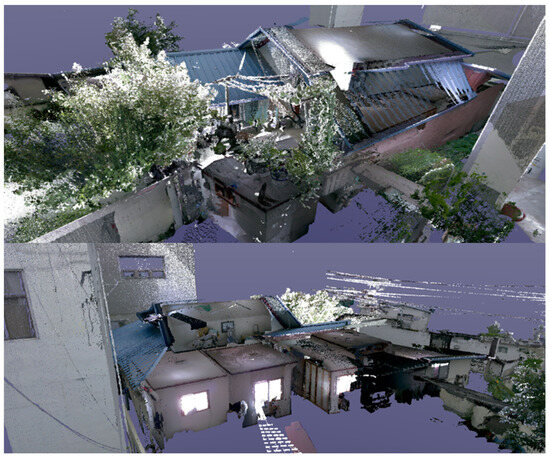
A point cloud is a digital collection of spatial data — each “point” representing a specific coordinate (X, Y, Z) in real-world space.
Captured through LiDAR or laser scanning, these datasets can contain millions of points, forming a complete 3D representation of a building, object, or terrain.
Architects and engineers use point cloud data to create accurate 3D models, generate as-built documentation, or develop Building Information Models (BIM) that reflect real conditions on-site.
Why Point Cloud Data Matters
Every architectural or engineering project begins with one essential need: accuracy.
Traditional surveys are limited in scope, while point cloud scanning captures even the most complex geometries in detail.
Key advantages include:
- Millimeter precision, crucial for both new and existing structures.
- Speed and efficiency, reducing manual measurement time.
- Enhanced safety, eliminating the need to access difficult or hazardous areas.
- Seamless BIM integration, enabling direct conversion to digital models.
For restoration, renovation, or construction management, point cloud data provides the foundation for smarter, data-driven decision-making.
From Raw Data to Intelligent Design
Collecting millions of data points is only the beginning.
The real value emerges when that data is processed, classified, and modeled — transforming the point cloud into usable architectural or engineering information.
Wolk Amsterdam specializes in this transformation.
By converting raw point cloud data into accurate BIM models and digital twins, the company bridges the gap between physical reality and digital design.
This process allows architects and developers to visualize, plan, and execute with full confidence in their data.
Applications Across Industries
The use of point cloud technology is rapidly expanding across multiple sectors:
- Architecture & Design – 3D scans for renovation, restoration, and concept modeling.
- Construction & Infrastructure – verification of as-built conditions and progress monitoring.
- Heritage Preservation – documentation of historical buildings with extreme detail.
- Real Estate & Facility Management – creation of digital twins for asset management.
- Urban Planning – integration of precise 3D mapping in smart city projects.
In each case, point cloud surveys deliver measurable improvements in efficiency, quality, and long-term sustainability.
The Future of Point Cloud Technology
As artificial intelligence, LiDAR sensors, and drone scanning continue to evolve, point cloud technology is becoming more automated, accessible, and scalable.
AI-driven segmentation now helps identify materials, surfaces, and structural components directly within the scan — drastically accelerating BIM workflows.
With this evolution, experts like Wolk Amsterdam are positioning the point cloud as a key component of the future digital construction ecosystem, where accuracy and efficiency go hand in hand.
In Summary
The point cloud represents more than just a technical advancement — it’s a revolution in how we capture, interpret, and build our world.
By turning complex environments into actionable digital data, companies such as Wolk Amsterdam are enabling architects, engineers, and planners to design with precision and confidence.
As digital transformation continues to shape the construction landscape, the point cloud stands as the foundation of smarter, safer, and more sustainable design.